A free, live density altitude badge for your airport's website
Show pilots today's density altitude at your field. It updates itself from the latest METAR — no signup, no script, nothing to maintain. Paste one line into any website.
- Free
- No signup
- No script
- Updates from the METAR
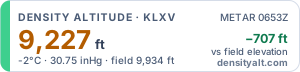
Get the badge for your airport
Light suits white pages (most city and county sites); dark suits dark ones.
Preview
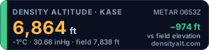
Just an image and a link, so it works anywhere a picture does, including locked-down city and county website systems.
A little more detail (pressure altitude, ISA deviation, airport name) and it refreshes itself every 15 minutes, handy on an FBO lobby screen.
Copy & paste
Image badge Recommended
Paste this into your page's HTML or "source" view. Nothing else to install.
<a href="https://densityalt.com/?icao=KASE"><img src="https://densityalt.com/badge/KASE.svg" width="300" height="72" alt="Live density altitude at KASE, from DensityAlt"></a>
Iframe card
For website builders with an "Embed" or "HTML" block.
<iframe src="https://densityalt.com/embed/KASE" width="320" height="190" style="border:0" loading="lazy" title="Live density altitude at KASE"></iframe>
Markdown
For forums, wikis and GitHub READMEs.
[](https://densityalt.com/?icao=KASE)
Plain link
For emailed newsletters, or anywhere images aren't allowed.
<a href="https://densityalt.com/?icao=KASE">Today's density altitude at KASE</a>
How do I paste this into my website?
- Open the page in your website editor and find its HTML or Source view (often a <> button), or add an HTML, Embed or Code block.
- Paste the code where you want the badge, then save or publish. That's it: it updates itself from then on.
- WordPress: a Custom HTML block. Squarespace: a Code block. Wix: Embed HTML. City and county systems (CivicPlus, Granicus and similar): switch the editor to Source/HTML view; if HTML is locked, ask your web administrator to paste the image badge for you.
- Emailed newsletters: many email apps, including Gmail and Outlook, don't show SVG images, so use the plain link there.
Pilots who click the badge land on the density altitude calculator for KASE, pre-filled with live weather.
Educational only — pilots should always use their POH and official weather for flight planning.
What the badge shows
Everything a pilot needs to judge the day at a glance, and enough detail to check the math. Here's the badge for KASE, shown at twice its normal size.
DENSITY ALTITUDE · KASEYour airportThe ICAO code the badge is for.8,498 ftDensity altitude right nowPressure altitude corrected for temperature: the altitude the airplane will actually perform like today.+676 ft vs field elevationHow much higher it "feels" than the fieldThe quickest read for pilots. It also sets the colour of the bar on the left and of this figure.7°C · 30.10 inHg · field 7,822 ftThe inputsTemperature, altimeter setting and field elevation behind the number, so pilots can sanity-check it.METAR 0453ZData source and timeThe observation it's based on, in Zulu (UTC). Another station's ID here means the nearest METAR was used; "model est." means a weather-model estimate.densityalt.comOne click to the full calculatorThe badge links to DensityAlt's calculator for your airport, pre-filled with the same live weather.
How it updates
- Each time someone opens your page, the badge shows the latest METAR for your field (from aviationweather.gov), cached for up to 10 minutes.
- The iframe card also refreshes itself every 15 minutes while it's on screen.
- No METAR at your field? It uses the nearest METAR within 25 nm, adjusts the temperature for any significant difference in elevation, and shows that station's ID and time.
- Nothing within 25 nm? It falls back to a weather-model estimate and labels it "model est." on the badge.
- Observations more than three hours old are skipped, and if no weather is available the badge says "Unavailable right now" rather than showing a stale number.
Every badge number uses the method our guide explains: how to calculate density altitude.
Why put density altitude on your site
Pilots already know the number matters. The badge puts it where they look before they come.
The number behind many hot-day mishaps
High density altitude is a well-known factor in takeoff and climb accidents at high-elevation airports, especially on summer afternoons. FAA guidance, including the Pilot's Handbook of Aeronautical Knowledge, tells pilots to account for it before every high, hot departure.
Transient pilots check your site first
Visiting pilots look up your runways, fuel and services before they fly in. A live density altitude right there tells a flatland pilot what your field will feel like today, and nudges them toward a cooler morning departure.
Zero maintenance
Paste it once. It updates itself from the METAR, with no account, plugin, API key or renewal, and nothing for your web team to touch again.
Who it's for
Airport managers
Put it on your pilot-information page next to runways and fuel. It's just an image and a link, so it works in locked-down city and county website systems.
FBOs
Show it beside fuel prices and services, or run the iframe card on a lobby or flight-planning screen.
Flight schools & clubs
Make density altitude part of every preflight: on your homepage, scheduling page or member portal.
Newsletters & blogs
Use the image badge in web posts and the Markdown version in forums. For emailed newsletters, use the plain link.
Light, private and fast
Nothing for IT or security to worry about.
- A plain image, about 1–2 KB. No JavaScript runs on your site.
- No cookies, no tracking scripts and no ads.
- Served from a CDN and cached, so it won't slow your page down.
- Accessible: descriptive alt text, and the image carries its own text label for screen readers.
Frequently asked questions
Is the badge really free?
Yes. There's no signup, no account and no API key, and there are no ads in the badge. Copy the code, paste it into your page, and you're done.
How current is the density altitude?
It's computed from the latest METAR for your field and cached for up to 10 minutes. Routine METARs are issued every hour, with extra reports when the weather changes, and the badge prints the observation time in Zulu so pilots can see exactly how fresh it is.
What if my airport has no METAR?
The badge uses the nearest METAR within 25 nm, adjusts its temperature for any significant difference in elevation, and shows that station's ID and time so pilots know where the numbers come from. If there's no reporting station within 25 nm, it uses a weather-model estimate and says "model est." on the badge.
Will it slow down my website?
No. The image badge is a plain SVG of about 1–2 KB, served from a CDN and cached. It runs no scripts and sets no cookies on your site. The iframe card is a tiny self-contained page that loads lazily.
Can I change the size or colours?
Pick the dark or light style above (the light one adds ?theme=light to the image address). The badge is a vector image, so you can scale it by changing the width and height attributes in proportion, for example width="450" height="108", and it stays sharp. The coloured bar follows the conditions (green, amber or red) and can't be changed.
Can pilots use the badge for flight planning?
No. It's an educational awareness tool that helps pilots notice when density altitude is high. For go/no-go decisions, pilots should use their aircraft's POH performance charts and official weather from a METAR, ATIS/AWOS or a standard briefing.
Questions or a custom size? Message Levan on LinkedIn.

Instrument-rated private pilot and the builder of DensityAlt, a free set of aviation calculators. The badge uses the same live-weather density altitude as the calculator and the Hot & High board. LinkedIn · GitHub